Skip to content Skip to footer
Lorem ipsum dolor sit amet, consectetur adipiscing elit. Ut elit tellus, luctus nec ullamcorper mattis, pulvinar dapibus leo.

Geo-awareness service

With the maps of this version of d-flight, the process of geo-referenced representation of the "Air Rules" applicable in Italy to support geo-awarness continues, based on the current legislation issued by ENAC .

A summary thematic map is now available on d-flight indicating the rules of the air for airspace below 120 meters, in relation to the following elements:

Cartographic ElementsData SourceStato su d-flight Visible / Deactivable for PRO User
Airports and civil heliports (IFR e VFR)AIP ITALIA AD.2ON 
Military airports for civil useCIRCOLARE ATM09 allegato fON 
eliavioidro authorized surfacesDB ENACON 
ATZ e CTR, where establishedAIP ITALIA AD.2ON 
Aeroporti MilitariDati AMI elaborati allegato AON 
Regulated AirSpace relativamente alle attività di:
Lancio paracadutisti;
Volo acrobatico;
Aeroclub e di lavoro aereo;
Volo da diporto sportivo (VDS)
AIP ITALIA:
ENR 5.5.1,
ENR 5.5.2,
ENR 5.5.3,
ENR 5.5.4
ON 
Prohibited areas (P)AIP ITALIA ENR 5.1.1ON 
Regulated areas ( R)AIP ITALIA ENR 5.1.2ON 
Dangerous areas (D)AIP ITALIA ENR 5.1.3ON 
Military firing rangesAIP ITALIA ENR 5.2.1ON 
Dedicated areas to military APRAIP ITALIA ENR 5.2.2.5ON 
Low-altitude military activity areasAIP ITALIA ENR 5.2.2.6ON 
Natural parks and areas subject to wildlife protectionAIP ITALIA ENR 5.6.1ON 
ATM-09D-flight processing of the circular starting from the above dataONV/D
Natural parks and areas subject to wildlife protection - supplementary layerNational Cartographic PortalONV
Census layerISTAT 2011 census dataONV/D
Ground use layerCORINE Land Cover 2018ONV/D

How to consult the Air Rules

Depending on the position of the cursor on the map, clicking with the right mouse button (or tapping on the screen on the point of interest and selecting the info (i) icon on mobile devices) will show information about the airspace above. In the event of overlapping of different rules, the most restrictive is applied. The pop-up that appears by clicking with the mouse on the map shows:

  • Maximum height allowed
  • Air rule, specific for the selected point
  • In Interested Areas the identification data are shown to facilitate the User in the eventual request for authorization to fly on that specific area. Below is the navigable list of all the other areas that are intersected by the selected point that can be used for detailed analysis by expert users.

Regulatory sources

The entire list of sources can be consulted on the ENAC website at the link https://www.enac.gov.it/sicurezza-aerea/droni/normativa-droni

E’ buona norma consultare i documenti pubblicati da ENAV in AIP Italia, dove è possibile accedere gratuitamente dopo una semplice registrazione. Infatti, l’attuale versione delle Mappe d-flight non riporta ancora in modo puntale (cioè nel pop-up attivo cliccando sulla mappa), le indicazioni calendariali (orari e giorni) che in alcuni casi consentono il volo, come ad esempio specificato in ENR 5.6.1 “Parchi naturali e zone soggette a protezione faunistica”. Per conoscere questi dettagli è, per ora, necessario consultare lo specifico documento ENR di riferimento. Per accedere alla cartografia AIP occorre consultare il sito ENAV all’indirizzo: https://www.enav.it/sites/private/it/ServiziOnline/AIP.html

Before using a drone it is important to inform yourself and understand the current civil aviation legislation, even if the flight is for recreational purposes. It is the operator's responsibility to ensure that the flight takes place safely and in compliance with the regulations. Careful observation of the context in which you intend to fly and the exact knowledge of the weather and geomagnetic conditions ensures that the use of the drone does not pose a danger to oneself and to others.

d-flight assumes no responsibility with respect to non-compliance with applicable regulations and improper use of drones. 

UAS Operator registration

Following accreditation on the d-flight portal, the user who intends to become a UAS operator must:

  • be credited on the d-flight platform with a valid subscription;
  • fill in the appropriate form "Op. UAS ”accessible from“ Account ”providing the requested data as reported in the user manual - section 1.5.4.
  • send the required documentation according to the instructions that will be sent to the registration email address.

QR-Code UAS Operator

The UAS operator already registered, obtains the QR code to be applied on the drones he intends to use

Il “QR Code Operatore” è un codice alfanumerico che consente di identificare univocamente un operatore UAS.L’operaore UAS è tenuto a stampare ed applicare is suo QR Code Operatore UAS sui mezzi in suo possesso, prima di impiegarli in volo.

Identification

The service allows the authority or private citizen (with exclusive reference to their data) to know some information about the vehicle, its operator and its owner, through the d-flight platform. 

For private citizens, reading the Operator QR Code anonymously (i.e. without having logged into the platform), through the reader on the d-flight web-app, provides information on the validity of the code. Instead, the reading of the Operator QR Code in authenticated mode (i.e. having logged in on the platform), through the reader on the d-flight web-app, provides information on the validity of the code and further detailed information.

The identification service is valid in all EU countries that have implemented the interoperability of the national UAS Operator registers.

Several lost UAS have been returned to their owners via the QR Code !! Don't underestimate this aspect! 

Declaration

Per effettuare operazioni in categoria specifica, in accordo agli scenari standard definiti dall’Autorità (cfr. linea guida ENAC), occorre rendere la dichiarazione tramite il servizio dichiarazione su questo portale.

Before accessing the service, the Operator must follow the administrative procedure referred to in the link https://www.enac.gov.it/sicurezza-aerea/droni/fatturazione-droni.

The declaration can only be issued by accredited users, with a valid PRO subscription, correctly registered as a UAS Operator, in association with a UAS vehicle in their availability, correctly inserted in their fleet, with an active UAS PRO QR Code.

Drone Operation Plan (DOP)

The Drone Operation Plan (DOP) service allows you to view the area of your operation and verify the compatibility between your mission area and the operations planned by other Operators in the same area and in the same time period.

Il servizio “Drone Operation Plan” (DOP) è obbligatorio per l’Operatore UAS che opera sulla base di autorizzazione dell’ENAC in BVLOS. Per altre tipologie di operazioni UAS, il servizio non è obbligatorio, ma il suo impiego costituisce un importante contributo alla situation awareness relativamente allo spazio aereo interessato dall’attività.

All accredited users with a valid PRO subscription, correctly registered as a UAS Operator, in association with a UAS vehicle in their availability, correctly inserted in their fleet, with an active UAS QR Code can access the DOP creation and activation service.

The detailed instructions for accessing the Service, completing and submitting the plan are given in Chapter 2 of the User Manual HERE QUI

Lorem ipsum dolor sit amet, consectetur adipiscing elit. Ut elit tellus, luctus nec ullamcorper mattis, pulvinar dapibus leo.

Registered user

The accreditation procedure allows users interested in the use of drones to be accredited on the d-flight portal for access to services reserved for operators. The registration procedure takes place by checking the main email linked to the user's profile.

Accreditation allows access to the geo-awareness service:

  • Visualization and interrogation of the Aeronautical Maps with the regulated areas for the drones flight
  • The visualization and interrogation of temporary airspace reserves
  • Navigating the map with normal WebGIS tools

Accreditation also allows:

  • User profile management and information including optional references to the flight qualifications certificates of the pilots in charge, ratings and licenses, in order to place their skills within a "Virtual Curriculum"
  • Fleet management: Users can enter the data associated with each drone in their possession
  • Subscription management (activation / renewal)
  • Registration as a UAS Operator (in the presence of an active subscription)

For accreditation, please refer to the video guides or user manual. Utmost care in indicating a valid email! In the case of certified e-mails, tick the appropriate box (indicating an invalid e-mail address, it will not be possible to confirm the credit. After 48 hours, the data will be deleted from the server and it will be possible to proceed with a new credit).

Subscription subscription

Some services provided by the d-flight platform are accessible only in the presence of an active subscription. After 12 months from the date of activation, the subscription can be renewed. The subscription allows registration as a UAS Operator, the release of the corresponding UAS Operator code according to the international format, the printing of the corresponding UAS Operator QR Code, the Identification service.

The active subscription also allows optional access to flight planning and tracking services (DOA and DOP) for which the activation of a "QR Code UAS" is also required for the vehicles included in your fleet, to the declaration service for SPECIFIC operations in Standard Scenarios, to value-added GIS services. The subscription gives access to the Service Desk service with incremental priority.

N.b. The expired subscription can be renewed after 24 hours from its expiration date. The system sends a reminder to the registration email a few days before the deadline.

The subscription is of the BASIC or PRO type. Private users can choose between the two modes, which correspond to distinct service levels. Legal entities can only activate the PRO subscription.

The credits required for the activation of a UAS QR Code can be purchased on d-flight store. To access the store, the following login credentials are used: the registration email used for crediting d-flight and the same password.

Methods of payment and billing for PA

Public administrations can also pay for purchases in "split payment bank transfer".

Regardless of the method of payment, the invoice will be issued using a "split payment" method.

The following e-mail box is also active supportopa@d-flight.it dedicated to Public Administration is also active for:

  • issue of a quote / quote order, invoice in advance of the transfer, or any supporting documentation (e.g. internal order, DURC, traceability of financial flows, etc.);

N.B. Support requests addressed by the user to said mailbox, unless related to the P.A. will not be consideredn such cases, please contact d-flight through the form available at this link

UAS QR-Code (optional)

Some services related to the use of the UA (e.g. DOA, DOP, declaration) are accessible only if the vehicle is correctly inserted in its fleet and optionally equipped with a UAS QR Code.

To activate the UAS QR Code, the user is required to be accredited, have a valid subscription, be registered as a UAS Operator, have entered the vehicle in his fleet and have indicated that he is the Operator of the UAS vehicle.

The credits required for the activation of a UAS QR Code can be purchased on d-flight store. To access the store, the following login credentials are used: the registration email used for crediting d-flight and the same password.

Lorem ipsum dolor sit amet, consectetur adipiscing elit. Ut elit tellus, luctus nec ullamcorper mattis, pulvinar dapibus leo.

Drone Operation Area (DOA)

Il servizio Drone Operation Area per missioni VLOS nella categoria OPEN ha una duplice valenza:

  • permette all’Operatore di verificare in modo rapido la compatibilità di un’area di volo VLOS con le limitazioni nell’utilizzo dello spazio aereo;
  • makes available to all registered users with active subscription, the "missions" in progress, displayed anonymously on the map of the d-flight portal.

Il servizio non è obbligatorio, ma costituisce un importante contributo alla situation awareness relativamente allo spazio aereo interessato dall’attività.

All accredited users with a valid subscription, correctly registered as a UAS Operator, in association with a UAS vehicle in their availability, correctly inserted in their fleet, with an active UAS QR Code can access the DOA creation and activation service.

Solo all’attivazione, la Drone Operation Area diventerà visibile sulla mappa a tutti gli utenti dflight loggati sul portale..È possibile avere una sola Drone Operation Area attiva o salvata per volta.

La visualizzazione da parte degli altri utenti sarà di tipo anonimo, in quanto il sistema non presenterà alcun dato riguardante l’utente (drone compreso) che ha pianificato ed attivato la missione. Il sistema non visualizzerà la posizione esatta del drone all’interno della Drone Operation Area, e non sarà generato nessun allarme riguardo al mancato rispetto dei parametri pianificati. Sarà obbligo del pilota rimanere nella zona pianificata, attenersi e rispettare le regole del volo applicate all’area di interesse.

Al termine della missione, l’Operatore dovrà cliccare “termina” nel pannello di Drone Operation Area, e l’area non sarà più visibile agli altri utenti. Se tale operazione non verrà fatta, il sistema rimuoverà tale area automaticamente dopo un tempo di time-out dallo start.

For the tutorial on using the Drone Operation Areawatch the video

Networking Remote e-Identification (NRI)

The service allows the user to share their position with d-flight. The position will be shared on the map, in pseudo-anonymous form (the drone license plate will be shown for the traces relating to the Drone Operation Plan, the user ID for the traces relating to the Drone Operation Area), with all other users logged in to the portal in relation to the area of interest, with a view to situation awareness.

To activate the service, simply accept the sending of the position by your device and at the date and time scheduled for the mission, access the "Drone Operation Plan" or "Drone Operation Area" service from a laptop or from a Mobile or from a Mobile App and start the mission (by clicking on Start / Launch). The service will then be interrupted upon completion of the mission or upon exceeding the mission end date / time.

To share the real position of the UAS during the flight you will need:

  • equip your drone with a device capable of sending all the necessary information to d-flight;
  • or equip your GCS with an application capable of sending all the necessary information to d-flight

A tal fine, d-flight ha reso pubblico un “Interface Control Document” (ICD) disponibile sul sito. Pur non essendo obbligatorio, d-flight promuove l’adozione e l’implementazione dell’ICD da parte degli operatori UAS e dei produttori di mezzi UAS interessati. Lo sviluppo del servizio di NRI consentirà il progressivo miglioramento della situation awareness relativamente allo spazio aereo interessato dall’attività UAS. Chi fosse interessato ad aderire all’iniziativa d-flight può scaricare il documento di ICD dal link:

N.b. Il download e l’utilizzo dell’ICD implica la presa visione e l’implicita accettazione dei termini definiti nella collegata Licenza d’uso sottostante:

Advanced GIS Services (PRO)

On d-flight, in addition to the basic Geo Awareness service, accessible to all accredited users, other value-added GIS services are available. Others are in development. The advanced GIS services are reserved for accredited users, with a valid PRO subscription. Additional GIS services may require additional access conditions.

Maps 

  • 'Aerial' - The map showing the orthophotos: geometrically correct and geo-referenced aerial photographs, so that the scale of representation of the photograph is uniform. The map can be considered equivalent to a geographical map
  • 'Road' - The map that displays vectorial images of roads, buildings and geography in a graphic manner. The map can be considered equivalent to a political map
  • 'Aerial Street' - The Aerial map that highlights the streets and main landmarks for easy identification of places through satellite images (in addition to the openstreetmap, already available on d-flight)
  •   'Dark' - Map optimized for night viewing

The 'Aerial', 'Road', 'Aerial Street', 'Dark' Maps include Google Bing data (the data from which the default road map is rendered is licensed by Navteq) and will allow PRO Operators to analyze in more detail the area of operations.

Layers

  •   'Land use' - which includes information relating to the environment on some priority issues for the European Union (air, water, soil, land cover, coastal erosion, biotopes, etc.)
  •  'Census' - which includes information on the number of inhabitants by census section

The 'Land use' layer includes the data provided by the CORINE 2018 project (a European program launched in 1985 by the European Commission) and will allow PRO Operators to carry out a preliminary analysis of the ground risk for the preparation of the SORA.

The 'Census' layer includes the ISTAT data from the 2011 census and will allow PRO Operators to carry out a preliminary analysis of the ground risk for the preparation of the SORA

To activate the Land Use and Census layers, click on the 'Show Layers' button and select the 'Soil' and / or 'Census' layer [Fig. 2]. NB. The 'Land Use' and 'Census' layers are visible when the zoom is equal to or greater than 1: 20,000 (Land Use) or 1: 50,000 (Census).

For the tutorial on the use of Maps and Layers for PRO userswatch the video.

GNSS Monitoring

Questo servizio permette agli utenti di visualizzare su mappa un’indicazione dell’eventuale stato di malfunzionamento del segnale GNSS.
Si può accedere al servizio cliccando con il pulsante destro sulla mappa: se il segnale GNSS è corrotto (ad es. a causa di problematiche su un satellite GNSS / interferenze dovute a fenomeni ionosferici significativi) appare nel pannello informativo un Alert (semaforo rosso) o un Warning (semaforo giallo) relativo allo stato del segnale nella regione di mappa selezionata

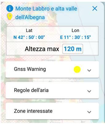
All accredited users with valid PRO subscription can access the GNSS Real Time Monitoring servic

In entrambe le condizioni di Alert e Warning è  fortemente sconsigliato il volo con navigazione basata esclusivamente su GNSS, poiché le prestazioni del segnale non risultano affidabili come da performance nominali.

The signal status is relative to reference conditions with respect to the ground. The service does not take into account the morphology of the terrain, or the actual condition of the drone - in other words, the GNSS signal could work in a nominal way (ie on the map there are no alarms) but if the user is inside a gorge or in the shadow of an obstacle, however the GNSS communication could be impaired and the flight affected. It is therefore recommended to also pay attention to the information available on the GCS.

Finally, in the event of an alarm, by clicking on the detail expansion arrow it is possible to consult the following values ​​on the GNSS signal:

  • Minimum HDOP: index of the quality of the satellite arrangement in the horizontal reference condition
    Minimum VDOP: index of the quality of the satellite arrangement in the vertical reference condition
  • Minimum elevation: the minimum elevation in degrees between the satellites visible in the reference condition (useful for evaluating the width of the local horizon, or the degree of visibility of the drone)
  • Hor error: the estimate of the error in meters in the horizontal reference condition
  • Error Up: the estimate of the error in meters in the vertical reference condition
  • HPL: maximum horizontal error in meters estimated by EGNOS in the reference condition
  • VPL: maximum vertical error in meters estimated by EGNOS in the reference conditio

Detailed instructions on the service are given in User Manual.

Lorem ipsum dolor sit amet, consectetur adipiscing elit. Ut elit tellus, luctus nec ullamcorper mattis, pulvinar dapibus leo.

Drone Detection System (DSS)

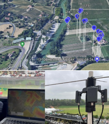
The UAS detection system DDS consists of a set of detection sensors, consisting of antennas and video cameras, and mitigation countermeasures, such as alarms.

This system, in its most complete form, allows you to identify up to 98.9% of the drones in the area and track their performance.

The strengths are:

  • early warning system,
  • tracking the position of the drone,
  • geo-location of the pilot,
  • automatic production of reports,
  • event log,
  • data integration in the d-flight platform.

Grazie a tale sistema appare chiaro l’incremento della Situational Awareness dell’intero U-space che si vuole tenere monitorato per motivi di ordine pubblico, in caso di eventi o a supporto del monitoraggio aereo di infrastrutture sensibili.


Call us
Free Number
Mon / Sat 9-19
Holidays excluded
Follow us on

D-FLIGHT S.p.A.
Via Salaria, 716 – 00138 Roma
Partita I.V.A. 14996981008
Reg. Imp. Roma – REA 1560988

Copyright © d-flight 2023 All rights reserved